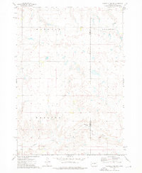
1973 Map of Chapelle Lake NW
USGS Topo · Published 1976About this map
Chapelle Creek meanders through the southern portion of this landscape, carving a subtle valley through the prairie of Hughes County and Hyde County. Surveyed in the early 1970s, the map documents a transition in land use and history, most notably marked by the Old Indian Treaty Boundary that cuts across the lower sections of the quadrangle. This line serves as a significant cartographic record of historical land agreements and divisions in the region.
Find a feature on this map
9 named features on this map. Tap any name to fly to it.
Don’t see what you’re looking for? This feature index may not catch every label — zoom into the map to look around manually.
Map Details
Editions of this 1973 Chapelle Lake NW Map
This is the sole edition of this map. No revisions or reprints were ever made.
Other maps of this area

1953 · Huron
USGS Topo · 1:250,000

1954 · Huron
USGS Topo · 1:250,000

1967 · Blunt SE
USGS Topo · 1:24,000

1967 · De Grey NE
USGS Topo · 1:24,000

1968 · Harrold
USGS Topo · 1:24,000

1968 · Holabird
USGS Topo · 1:24,000

1973 · Chapelle Lake SE
USGS Topo · 1:24,000

1973 · De Grey SE
USGS Topo · 1:24,000

1973 · Chapelle Lake SW
USGS Topo · 1:24,000

1973 · Chapelle Lake
USGS Topo · 1:24,000