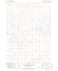
1978 Map of Thomas Lake
USGS Topo · Published 1978About this map
Medicine Knoll Creek flows through this portion of Hyde County, South Dakota, defining a landscape marked by scattered prairie wetlands and small-scale rural infrastructure. The late-1970s survey illustrates a persistent agrarian pattern, where local community centers like Sedgwick Ch and Franklin Sch served the surrounding townships. Water dominates the central terrain, with Thomas Lake and the larger Spring Lake providing significant landmarks in an area otherwise characterized by intermittent drainage and sections of the Illinois township boundary.
Find a feature on this map
9 named features on this map. Tap any name to fly to it.
Don’t see what you’re looking for? This feature index may not catch every label — zoom into the map to look around manually.
Map Details
Editions of this 1978 Thomas Lake Map
This is the sole edition of this map. No revisions or reprints were ever made.
Other maps of this area

1949 · Mitchell Lake
USGS Topo · 1:24,000

1950 · Mitchell Lake
USGS Topo · 1:24,000

1951 · Rice Lake
USGS Topo · 1:24,000

1951 · Rezac Lake NW
USGS Topo · 1:24,000

1953 · Huron
USGS Topo · 1:250,000

1954 · Huron
USGS Topo · 1:250,000

1968 · Harrold NW
USGS Topo · 1:24,000

1968 · Harrold NE
USGS Topo · 1:24,000
1978 · Bald Hills
USGS Topo · 1:24,000
1978 · Thomas Lake SW
USGS Topo · 1:24,000