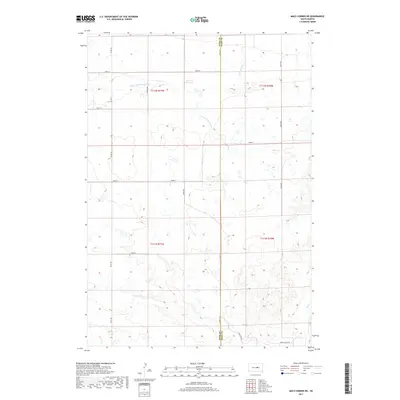
2017 Map of Macs Corner NE
USGS Topo · Published 2017About this map
Hyde Co Hand Co marks the central north-south dividing line of this agricultural landscape in the late 2010s. The terrain is defined by a series of intermittent watercourses that drain the prairie, most notably the meandering S Fork Medicine Knoll Cr which cuts through the northern sections. This survey illustrates the rigid, square-mile township and range system typical of the Great Plains, where section lines are almost exclusively utilized as the local road network. Secondary routes like Green Valley Rd and Co Rd 959 provide the primary transit through the area, connecting isolated farmsteads. Smaller drainages including Little Wolf Cr and Elm Cr further reveal the natural hydrology that dictates the placement of field boundaries and remaining uncultivated wetlands.
Find a feature on this map
15 named features on this map. Tap any name to fly to it.
Don’t see what you’re looking for? This feature index may not catch every label — zoom into the map to look around manually.
Map Details
Editions of this 2017 Macs Corner NE Map
This is the sole edition of this map. No revisions or reprints were ever made.
Other maps of this area

1950 · Highmore
USGS Topo · 1:24,000

1950 · Ree Heights
USGS Topo · 1:24,000

1950 · Highmore SE
USGS Topo · 1:24,000

1953 · Huron
USGS Topo · 1:250,000

1954 · Huron
USGS Topo · 1:250,000

1973 · Macs Corner NE
USGS Topo · 1:24,000

1973 · Miller Dale Colony SW
USGS Topo · 1:24,000

1973 · Macs Corner SE
USGS Topo · 1:24,000
1973 · Miller Dale Colony NW
USGS Topo · 1:24,000

1973 · Macs Corner
USGS Topo · 1:24,000