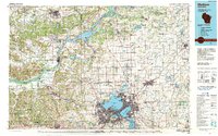
1991 Map of Madison
USGS Topo · Published 1991About this map
Madison and its surrounding glacial lakes serve as the focal point for this topographical study of South Central Wisconsin. The capital city is depicted during a period of significant regional integration, showing the dense urban core concentrated between Lake Mendota and Lake Monona, extending south toward Fitchburg and west to Middleton. The map captures the prominent academic and political landscape of the era, from the University of Wisconsin campus and the State Capitol to landmarks like Forest Hill Cem.
Find a feature on this map
195 named features on this map. Tap any name to fly to it.
Don’t see what you’re looking for? This feature index may not catch every label — zoom into the map to look around manually.
Map Details
Editions of this 1991 Madison Map
This is the sole edition of this map. No revisions or reprints were ever made.
Other maps of this area

1889 · Evansville
USGS Topo · 1:62,500

1890 · Madison
USGS Topo · 1:62,500

1890 · Sun Prairie
USGS Topo · 1:62,500

1890 · Stoughton
USGS Topo · 1:62,500

1891 · Waterloo
USGS Topo · 1:62,500

1891 · Koshkonong
USGS Topo · 1:62,500

1892 · Madison
USGS Topo · 1:62,500

1894 · Waterloo
USGS Topo · 1:62,500

1894 · Evansville
USGS Topo · 1:62,500

1894 · Koshkonong
USGS Topo · 1:62,500