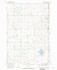
1968 Map of Madison NW
USGS Topo · Published 1971About this map
Spring Lake and the wetlands of the Prairie Coteau define this rural South Dakota landscape as it was documented in the late 1960s. The region is marked by a complex network of glacial depressions, including Lake Badus, Dry Lake, and Dooley Slough, which feed into the meandering course of Battle Creek. This geography created a challenging environment for early infrastructure, yet the Chicago Milwaukee St Paul and Pacific railroad successfully cut across the southwestern corner of the quadrangle, linking these isolated agricultural townships to broader markets. Local history is anchored by St Anns Cem, located near the shores of Lake Badus, serving as a silent record of the families who settled this area of Lake County. The map also identifies a National Wildlife Management Area, highlighting the early efforts to preserve the critical waterfowl habitat provided by these natural basins and sloughs.
Find a feature on this map
15 named features on this map. Tap any name to fly to it.
Don’t see what you’re looking for? This feature index may not catch every label — zoom into the map to look around manually.
Map Details
Editions of this 1968 Madison NW Map
This is the sole edition of this map. No revisions or reprints were ever made.
Other maps of this area

1953 · Watertown
USGS Topo · 1:250,000

1958 · Watertown
USGS Topo · 1:250,000

1968 · Lake Sinai
USGS Topo · 1:24,000

1968 · Lake Preston East
USGS Topo · 1:24,000

1968 · Arlington
USGS Topo · 1:24,000

1968 · Ramona
USGS Topo · 1:24,000

1968 · Madison
USGS Topo · 1:24,000

1968 · Sinai
USGS Topo · 1:24,000

1968 · Oldham
USGS Topo · 1:24,000

1968 · Oldham SE
USGS Topo · 1:24,000
Featured Places
- Spring Lake Hutterite Colony, SD
- Nunda Township, SD
- Wayne Township, SD
- Badus Township, SD
- Lake Sinai Township, SD