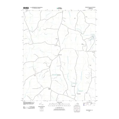
2010 Map of Madisonville
USGS Topo · Published 2010About this map
Madisonville serves as a central hub in this part of Charlotte County, where the landscape is defined by a dense network of creek branches and small upland ridges. The terrain rises toward Lyle Mountain and Baker Mountain, providing topographic relief in an area primarily shaped by the headwaters of Butterwood Creek and Rough Creek. This 2010 survey reflects a rural landscape where water management is prominent, evidenced by a series of modern reservoirs and water control structures like Roanoke Creek Site 4a Lake and Roanoke Creek Number 5b Dam. Genealogy researchers will find several well-placed burial grounds across the quadrangle, including Mount Lyle Cemetery and Oaks Cemetery. The presence of Maloney Siding and Wards Fork Mill points to the area's ongoing connection to historical transport and processing sites, even as modern residential roads like Llama Rd and Windy Hill Ln have emerged.
Find a feature on this map
51 named features on this map. Tap any name to fly to it.
Don’t see what you’re looking for? This feature index may not catch every label — zoom into the map to look around manually.
Map Details
Editions of this 2010 Madisonville Map
This is the sole edition of this map. No revisions or reprints were ever made.
Other maps of this area

1892 · Appomattox
USGS Topo · 1:125,000

1947 · Roanoke
USGS Topo · 1:250,000

1956 · Brookneal
USGS Topo · 1:62,500

1956 · Charlotte Court House
USGS Topo · 1:62,500

1958 · Appomattox
USGS Topo · 1:62,500

1958 · Pamplin City
USGS Topo · 1:62,500

1959 · Roanoke
USGS Topo · 1:250,000

1963 · Roanoke
USGS Topo · 1:250,000
1967 · Prospect
USGS Topo · 1:24,000
1968 · Red House
USGS Topo · 1:24,000