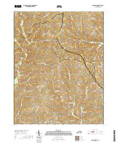
2019 Map of Madisonville
USGS Topo · Published 2019About this map
Madisonville and the hamlet of Taro anchor this rural landscape along the borders of Charlotte, Appomattox, and Prince Edward counties. The terrain is defined by the headwaters of numerous drainages, including Cub Cr and Spring Cr, which carve through the Piedmont hills. A series of flood control structures, including Roanoke Cr Site 4a Lake, Roanoke Cr Site 5b Lake, and Roanoke Cr Site 6a Lake, indicate modern water management efforts in the Roanoke Creek watershed. For researchers, several small burial grounds such as Salem Cem and Mount Lyle Cem are documented near established landmarks like Lyle Mtn. The dense network of secondary roads, such as Little Cub Rd and Darlington Heights Rd, reflects the long-standing agricultural and residential patterns of this central Virginia interior.
Find a feature on this map
83 named features on this map. Tap any name to fly to it.
Don’t see what you’re looking for? This feature index may not catch every label — zoom into the map to look around manually.
Map Details
Editions of this 2019 Madisonville Map
This is the sole edition of this map. No revisions or reprints were ever made.
Other maps of this area

1892 · Appomattox
USGS Topo · 1:125,000

1947 · Roanoke
USGS Topo · 1:250,000

1956 · Brookneal
USGS Topo · 1:62,500

1956 · Charlotte Court House
USGS Topo · 1:62,500

1958 · Appomattox
USGS Topo · 1:62,500

1958 · Pamplin City
USGS Topo · 1:62,500

1959 · Roanoke
USGS Topo · 1:250,000

1963 · Roanoke
USGS Topo · 1:250,000
1967 · Prospect
USGS Topo · 1:24,000
1968 · Red House
USGS Topo · 1:24,000