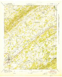
1941 Map of Madisonville
USGS Topo · Published 1941About this map
The Madisonville town site and the surrounding Monroe County landscape are defined by a complex network of ridges and watercourses as they appeared in 1941. The Louisville and Nashville railroad serves as the primary industrial spine, cutting across a terrain marked by the Bat Creek Knobs and the Knobs to the southeast. This era shows a high density of rural social infrastructure, including numerous small country schools like Sequoyah Sch and Cedar Grove Sch, alongside established institutions like Hiwassee College.
Find a feature on this map
51 named features on this map. Tap any name to fly to it.
Don’t see what you’re looking for? This feature index may not catch every label — zoom into the map to look around manually.
Map Details
Editions of this 1941 Madisonville Map
This is the sole edition of this map. No revisions or reprints were ever made.
Other maps of this area

1893 · Murphy
USGS Topo · 1:125,000

1895 · Loudon
USGS Topo · 1:125,000

1914 · Murphy
USGS Topo · 1:125,000

1933 · Haw Knob
USGS Topo · 1:48,000

1933 · Rafter
USGS Topo · 1:24,000

1934 · Mount Vernon
USGS Topo · 1:24,000

1934 · Englewood
USGS Topo · 1:24,000

1935 · Tellico
USGS Topo · 1:48,000

1935 · Meadow
USGS Topo · 1:24,000

1935 · Philadelphia
USGS Topo · 1:24,000