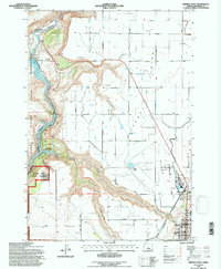
1992 Map of Madras West
USGS Topo · Published 1997About this map
Agency Plains and the irrigation-dependent landscape of central Oregon are documented in this 1990s-era revision. The topography is dominated by the dramatic descent from the agricultural plateau into the canyon of the Deschutes River, where Lake Simtustus is formed behind Pelton Dam. The map details the complex water management system essential to the region, including the North Unit Main Canal and several quarries.
Find a feature on this map
47 named features on this map. Tap any name to fly to it.
Don’t see what you’re looking for? This feature index may not catch every label — zoom into the map to look around manually.
Map Details
Editions of this 1992 Madras West Map
This is the sole edition of this map. No revisions or reprints were ever made.
Other maps of this area

1928 · Madras
USGS Topo · 1:125,000

1931 · Madras
USGS Topo · 1:125,000

1955 · Bend
USGS Topo · 1:250,000

1957 · Bend
USGS Topo · 1:250,000

1958 · Bend
USGS Topo · 1:250,000

1962 · Eagle Butte
USGS Topo · 1:24,000
1962 · Seekseequa Junction
USGS Topo · 1:24,000

1962 · Gateway
USGS Topo · 1:24,000
1962 · Round Butte Dam
USGS Topo · 1:24,000
1963 · Culver
USGS Topo · 1:24,000