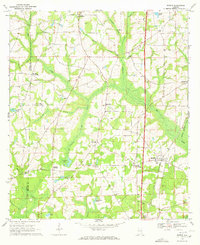
1969 Map of Madrid
USGS Topo · Published 1972About this map
The Atlanta and Saint Andrews Bay railroad anchors the local geography of southeastern Alabama, running south through Madrid toward the Florida line. This 1969 landscape is defined by its agricultural crossroads and small community centers like Rehobeth and Garretts Crossroads. The terrain is deeply etched by a network of waterways including Chipola Creek and Big Creek, which feed into low-lying areas like Coopers Bay. The map reveals a high density of rural spiritual and memorial sites, such as St Phillips Cem, St Peters Ch, and New Providence Ch, many of which represent long-standing family and community anchors. The division between Geneva and Houston counties is clearly delineated, showing how political boundaries intersect with natural features like Chestnut Branch.
Find a feature on this map
41 named features on this map. Tap any name to fly to it.
Don’t see what you’re looking for? This feature index may not catch every label — zoom into the map to look around manually.
Map Details
Editions of this 1969 Madrid Map
2 editions found
Other maps of this area

1942 · Enterprise
USGS Topo · 1:125,000

1951 · Graceville
USGS Topo · 1:24,000

1952 · Campbellton
USGS Topo · 1:24,000

1952 · Sills
USGS Topo · 1:24,000

1953 · Dothan
USGS Topo · 1:250,000

1954 · Dothan
USGS Topo · 1:250,000

1954 · Tallahassee
USGS Topo · 1:250,000

1955 · Dothan
USGS Topo · 1:250,000

1957 · Malvern
USGS Topo · 1:24,000

1957 · Hartford
USGS Topo · 1:62,500