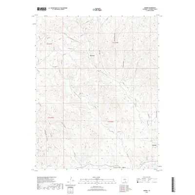
2019 Map of Madrid
USGS Topo · Published 2019About this map
The Purgatoire River winds through the southern reaches of this landscape, carving the Picketwire Valley and supporting the small settlements of Tijeras and Madrid. Located in Las Animas County, this region is defined by a series of deep canyons, including Chinamans Canyon, Wolf Canyon, and Burro Canyon, which segment the high ground. The presence of Coal Mine Dr near the western edge and the established settlement of Cokedale to the east reflects the area's deep-rooted coal mining heritage. Genealogists and local historians can find two notable burial grounds here: the Burro Canyon Cem situated near the canyon floor and the San Juan Cem to the southwest. To the north, the community of Boncarbo sits amidst a network of county roads and drainage systems like Reilly Canyon, illustrating the dispersed residential patterns typical of this mountainous terrain.
Find a feature on this map
54 named features on this map. Tap any name to fly to it.
Don’t see what you’re looking for? This feature index may not catch every label — zoom into the map to look around manually.
Map Details
Editions of this 2019 Madrid Map
This is the sole edition of this map. No revisions or reprints were ever made.
Other maps of this area

1891 · Spanish Peaks
USGS Topo · 1:125,000

1893 · Spanish Peaks
USGS Topo · 1:125,000

1895 · Spanish Peaks
USGS Topo · 1:125,000

1897 · Spanish Peaks
USGS Topo · 1:125,000

1900 · Spanish Peaks
USGS Topo · 1:125,000

1951 · Trinidad
USGS Topo · 1:24,000

1951 · Valdez
USGS Topo · 1:24,000

1951 · Madrid
USGS Topo · 1:24,000
1951 · Starkville
USGS Topo · 1:24,000

1954 · Trinidad
USGS Topo · 1:250,000