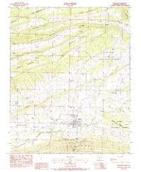
1983 Map of Magazine
USGS Topo · Published 1983About this map
Magazine stands as the central hub of this Logan County landscape in the early 1980s, situated where the valley floor meets the rising slopes of the Ozark National Forest. The geography is defined by a series of prominent east-west ridges, including Backbone Mountain and Pisgah Mountain, which channel the flow of local waterways like Sixmile Creek and Chigger Creek. The southern edge of the map is dominated by the winding course of the Petit Jean River, crossed by landmarks such as the Kilburn Bridge and First Bridge. This era shows a well-established network of rural cemeteries, including the Old Union-Cumberland Cem and Ellington Cem, which alongside the High School in Magazine, serve as vital anchors for the surrounding community. The presence of the Booneville Municipal Airport on the western edge highlights the regional transportation infrastructure during this period of the late twentieth century.
Find a feature on this map
50 named features on this map. Tap any name to fly to it.
Don’t see what you’re looking for? This feature index may not catch every label — zoom into the map to look around manually.
Map Details
Editions of this 1983 Magazine Map
This is the sole edition of this map. No revisions or reprints were ever made.
Other maps of this area

1879 · Mountain Home
USGS Topo · 1:62,500

1887 · Magazine Mountain #1
USGS Topo · 1:62,500

1887 · Magazine Mountain #4
USGS Topo · 1:62,500

1887 · Magazine Mountain #2
USGS Topo · 1:62,500

1887 · Magazine Mountain #3
USGS Topo · 1:62,500

1887 · Magazine Mountain
USGS Topo · 1:62,500

1890 · Magazine Mountain
USGS Topo · 1:125,000

1934 · Booneville
USGS Topo · 1:48,000

1939 · Booneville
USGS Topo · 1:62,500

1956 · Russellville
USGS Topo · 1:250,000