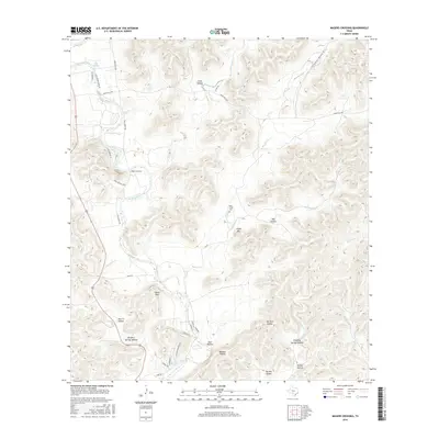
2016 Map of Magers Crossing
USGS Topo · Published 2016About this map
The Frio River carves a winding path through this corner of the Texas Hill Country, anchoring life and transport in a landscape defined by deep drainages and limestone uplands. Small settlements like Magers Crossing and Seven Bluff sit along the riverbanks, where the water has shaped both the terrain and the local history of ranching and recreation. The upland reaches are marked by numerous named draws such as Hog Hollow, East Hollow, and Van Pelt Hollow, which feed into tributaries like Bear Cr and Blanket Cr.
Find a feature on this map
43 named features on this map. Tap any name to fly to it.
Don’t see what you’re looking for? This feature index may not catch every label — zoom into the map to look around manually.
Map Details
Editions of this 2016 Magers Crossing Map
This is the sole edition of this map. No revisions or reprints were ever made.
Other maps of this area

1898 · Uvalde
USGS Topo · 1:125,000

1899 · Uvalde
USGS Topo · 1:125,000

1954 · San Antonio
USGS Topo · 1:250,000

1956 · Utopia
USGS Topo · 1:62,500

1957 · San Antonio
USGS Topo · 1:250,000

1957 · York Hollow
USGS Topo · 1:62,500

1960 · Concan
USGS Topo · 1:24,000

1960 · Magers Crossing
USGS Topo · 1:24,000
1969 · Vanderpool
USGS Topo · 1:24,000
1969 · Trio
USGS Topo · 1:24,000