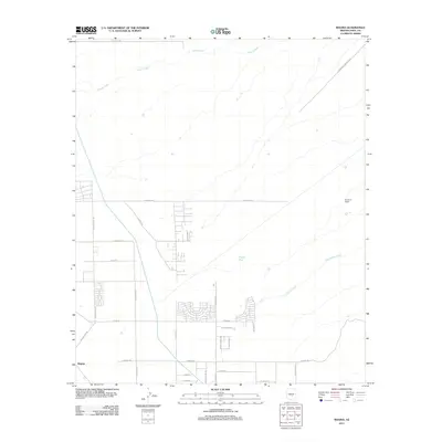
2011 Map of Magma
USGS Topo · Published 2011About this map
Queen Creek meanders across the northern portion of this arid landscape, setting the stage for a region defined by its wide washes and evolving residential grid. The settlement of Magma and the Ellsworth Ranch anchor the local geography, with the latter positioned near the banks of Cottonwood Creek. The map reveals a transition from traditional ranching lands to more formal subdivisions, as seen in the expanding road networks south of E Skyline Dr. Several large drainage features, including Magma Wash, cut through the terrain, illustrating the natural water management systems of the Pinal County desert. This 2011 survey documents a specific moment of development where thoroughfares like N Attaway Rd and E Magma Rd connect emerging neighborhoods with the surrounding agricultural and ranching history of the area.
Find a feature on this map
29 named features on this map. Tap any name to fly to it.
Don’t see what you’re looking for? This feature index may not catch every label — zoom into the map to look around manually.
Map Details
Editions of this 2011 Magma Map
This is the sole edition of this map. No revisions or reprints were ever made.
Other maps of this area

1900 · Florence
USGS Topo · 1:125,000

1902 · Florence
USGS Topo · 1:125,000

1904 · Desert Well
USGS Topo · 1:62,500

1906 · Desert Well
USGS Topo · 1:62,500

1907 · Sacaton
USGS Topo · 1:62,500

1954 · Mesa
USGS Topo · 1:250,000

1956 · Sacaton NE
USGS Topo · 1:24,000

1956 · Magma
USGS Topo · 1:24,000

1956 · Desert Well
USGS Topo · 1:24,000
1956 · Superstition Mts. SW
USGS Topo · 1:24,000