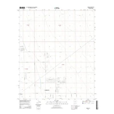
2014 Map of Magma
USGS Topo · Published 2014About this map
Florence and the community of Magma occupy a landscape shaped by both natural drainage and modern hydraulic engineering. The massive Central Arizona Project Aqueduct cuts a diagonal path through the western half of the map, representing a significant infrastructure development in the arid Gila River Valley. This man-made waterway contrasts sharply with the ephemeral, braided patterns of Queen Cr, Magma Wash, and Cottonwood Cr, which define the natural flow of the region. The map reveals a transitioning desert environment where agricultural roots and open land are increasingly intersected by residential street grids, such as the developments along E Desert Mountain Blvd and E Victor Way. Established rural corridors like N Attaway Rd and N Felix Rd remain central to the local transportation network, anchoring the area's ongoing expansion.
Find a feature on this map
44 named features on this map. Tap any name to fly to it.
Don’t see what you’re looking for? This feature index may not catch every label — zoom into the map to look around manually.
Map Details
Editions of this 2014 Magma Map
This is the sole edition of this map. No revisions or reprints were ever made.
Other maps of this area

1900 · Florence
USGS Topo · 1:125,000

1902 · Florence
USGS Topo · 1:125,000

1904 · Desert Well
USGS Topo · 1:62,500

1906 · Desert Well
USGS Topo · 1:62,500

1907 · Sacaton
USGS Topo · 1:62,500

1954 · Mesa
USGS Topo · 1:250,000

1956 · Sacaton NE
USGS Topo · 1:24,000

1956 · Magma
USGS Topo · 1:24,000

1956 · Desert Well
USGS Topo · 1:24,000
1956 · Superstition Mts. SW
USGS Topo · 1:24,000