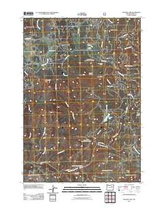
2011 Map of Magone Lake
USGS Topo · Published 2011About this map
Magone Lake sits as the central landmark of this high-elevation terrain in Grant County, surrounded by a complex network of forest camps and seasonal clearings. These sites, including Huckleberry Camp, Telephone Spring Camp, and Cold Spring Camp, suggest a landscape historically defined by forestry management and seasonal occupation within the national forest system. The drainage patterns are clearly defined by the headwaters of Long Creek, Lake Creek, and the East Fork Beech Creek, which carve through a series of meadows like Flood Meadow and Morrow Meadow. This 2011 survey captures the area at a time when remote outposts like the Herburger Cabin and Porcupine Camp remained significant points of reference for navigation. The presence of numerous named peaks such as Jonas Mountain, Lake Butte, and Nipple Butte provides a framework for understanding the topographic relief that separates these distinct high-country basins.
Find a feature on this map
37 named features on this map. Tap any name to fly to it.
Don’t see what you’re looking for? This feature index may not catch every label — zoom into the map to look around manually.
Map Details
Editions of this 2011 Magone Lake Map
This is the sole edition of this map. No revisions or reprints were ever made.
Other maps of this area

1940 · Mount Vernon
USGS Topo · 1:62,500

1940 · John Day
USGS Topo · 1:62,500

1943 · John Day
USGS Topo · 1:62,500

1943 · Mount Vernon
USGS Topo · 1:62,500

1949 · Long Creek
USGS Topo · 1:62,500

1949 · Susanville
USGS Topo · 1:62,500

1951 · Susanville
USGS Topo · 1:62,500

1951 · Long Creek
USGS Topo · 1:62,500

1955 · Canyon City
USGS Topo · 1:250,000

1959 · Canyon City
USGS Topo · 1:250,000