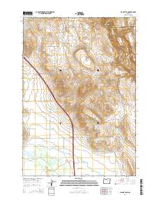
2014 Map of Magpie Peak
USGS Topo · Published 2014About this map
Magpie Peak and the Farley Hills dominate this portion of the high desert landscape along the border of Union and Baker Counties. The southern half of the quadrangle transitions into the fertile lowlands of Baker Valley, where the Powder River and Baldock Slough provide a network of water for the agricultural community of Missouri Flat. This area is defined by a complex irrigation system of channels, including Lillard Ditch and Swinger Ditch, which support the ranches and farms scattered throughout the valley floor.
Find a feature on this map
30 named features on this map. Tap any name to fly to it.
Don’t see what you’re looking for? This feature index may not catch every label — zoom into the map to look around manually.
Map Details
Editions of this 2014 Magpie Peak Map
This is the sole edition of this map. No revisions or reprints were ever made.
Other maps of this area

1901 · Baker City
USGS Topo · 1:125,000

1906 · Telocaset
USGS Topo · 1:125,000

1955 · Baker
USGS Topo · 1:250,000

1955 · Grangeville
USGS Topo · 1:250,000

1959 · Baker
USGS Topo · 1:250,000

1959 · Grangeville
USGS Topo · 1:250,000

1965 · Medical Springs
USGS Topo · 1:24,000
1965 · North Powder
USGS Topo · 1:24,000
1965 · Telocaset
USGS Topo · 1:24,000

1967 · Virtue Flat
USGS Topo · 1:24,000