
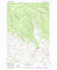
1965 Map of Medical Springs
USGS Topo · Published 1967About this map
Medical Springs and Pondosa serve as the primary landmarks in this high-altitude landscape of the Whitman National Forest in Union County. The topography is defined by significant elevations such as Reeves Mtn and Frazier Mtn, while the drainage network is anchored by Catherine Creek and its diverse tributaries, including Milk Creek and Cusick Creek. The placement of Fisk Reservoir illustrates mid-century water management in this timber-rich region.
Find a feature on this map
34 named features on this map. Tap any name to fly to it.
Don’t see what you’re looking for? This feature index may not catch every label — zoom into the map to look around manually.
Map Details
Editions of this 1965 Medical Springs Map
2 editions found
Other maps of this area

1901 · Baker City
USGS Topo · 1:125,000

1906 · Telocaset
USGS Topo · 1:125,000

1955 · Baker
USGS Topo · 1:250,000

1955 · Grangeville
USGS Topo · 1:250,000

1959 · Baker
USGS Topo · 1:250,000

1959 · Grangeville
USGS Topo · 1:250,000

1965 · China Cap
USGS Topo · 1:24,000

1965 · Flagstaff Butte
USGS Topo · 1:24,000

1965 · Union
USGS Topo · 1:24,000

1965 · Little Catherine Creek
USGS Topo · 1:24,000