
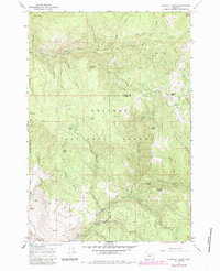
1965 Map of Flagstaff Butte
USGS Topo · Published 1967About this map
Wallowa-Whitman National Forest dominates this mid-1960s survey along the boundary of Union and Baker counties. The landscape is defined by the headwaters of Catherine Creek and its South Fork, which carve through the high country surrounding Flagstaff Butte. The map reveals a remote territory accessed primarily by a network of pack trails and jeep trails, indicating the land’s use for forestry and back-country recreation.
Find a feature on this map
40 named features on this map. Tap any name to fly to it.
Don’t see what you’re looking for? This feature index may not catch every label — zoom into the map to look around manually.
Map Details
Editions of this 1965 Flagstaff Butte Map
2 editions found
Other maps of this area

1901 · Baker City
USGS Topo · 1:125,000

1906 · Telocaset
USGS Topo · 1:125,000

1915 · Pine
USGS Topo · 1:125,000

1954 · Eagle Cap
USGS Topo · 1:62,500

1955 · Baker
USGS Topo · 1:250,000

1955 · Grangeville
USGS Topo · 1:250,000

1957 · Sparta
USGS Topo · 1:62,500

1959 · Baker
USGS Topo · 1:250,000

1959 · Grangeville
USGS Topo · 1:250,000

1965 · China Cap
USGS Topo · 1:24,000