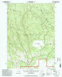
1996 Map of Magpie Table
USGS Topo · Published 1998About this map
Malheur National Forest dominates this high-altitude landscape along the border of Grant Co and Harney Co, Oregon. The terrain is defined by dramatic elevations such as Glass Mountain and Frazier Point, punctuated by the flat expanse of the Magpie Table and Cougar Flat. This 1990s survey by the Forest Service and USGS reveals a landscape meticulously managed for water and livestock, evidenced by the high density of named water sources like Frost Mill Spring, Lucky Reservoir, and Pierpont Spring. The drainage patterns of East Fork Middle Fork and West Fork Middle Fork carve through the forest, while specialized administrative zones like the Burns Ranger District and Prairie City Ranger District oversee the vast timber and rangelands. Small-scale industrial activity is noted at a Quarry near Tureman Creek, suggesting the local extraction of materials for forest road maintenance.
Find a feature on this map
44 named features on this map. Tap any name to fly to it.
Don’t see what you’re looking for? This feature index may not catch every label — zoom into the map to look around manually.
Map Details
Editions of this 1996 Magpie Table Map
This is the sole edition of this map. No revisions or reprints were ever made.
Other maps of this area

1955 · Burns
USGS Topo · 1:250,000

1955 · Canyon City
USGS Topo · 1:250,000

1958 · Burns
USGS Topo · 1:250,000

1959 · Burns
USGS Topo · 1:250,000

1959 · Canyon City
USGS Topo · 1:250,000

1961 · Calamity Butte
USGS Topo · 1:62,500

1961 · Logan Valley
USGS Topo · 1:62,500

1961 · Seneca
USGS Topo · 1:62,500

1968 · Van
USGS Topo · 1:62,500

1978 · John Day
USGS Topo · 1:100,000