
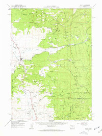
1961 Map of Seneca
USGS Topo · Published 1963About this map
Seneca stands as a focal point of this high-plateau region, situated at the confluence of the Silvies River and Bear Creek within the vast Malheur National Forest. The landscape is defined by the broad expanse of Bear Valley and Antelope Valley, where timber and ranching operations are evidenced by the Oregon Northwestern Railroad line and numerous logging roads. Named landmarks like Charlie Smith Butte and Jump-off Joe Mtn rise above the valleys, while the presence of the Maitland Airstrip and Silvies Landing suggest the remote infrastructure required for forest management and local commerce in the early 1960s.
Find a feature on this map
102 named features on this map. Tap any name to fly to it.
Don’t see what you’re looking for? This feature index may not catch every label — zoom into the map to look around manually.
Map Details
Editions of this 1961 Seneca Map
2 editions found
Other maps of this area

1940 · Mount Vernon
USGS Topo · 1:62,500

1940 · John Day
USGS Topo · 1:62,500

1943 · John Day
USGS Topo · 1:62,500

1943 · Mount Vernon
USGS Topo · 1:62,500

1955 · Burns
USGS Topo · 1:250,000

1955 · Canyon City
USGS Topo · 1:250,000

1958 · Burns
USGS Topo · 1:250,000

1959 · Burns
USGS Topo · 1:250,000

1959 · Canyon City
USGS Topo · 1:250,000

1959 · West Myrtle Butte
USGS Topo · 1:62,500