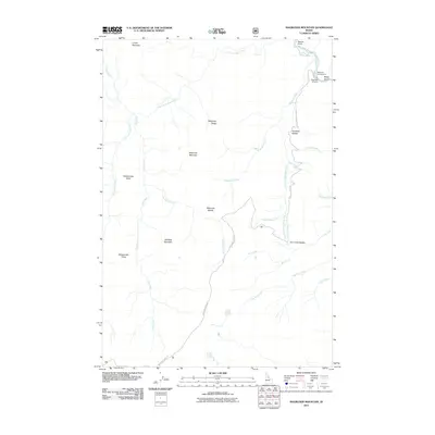
2011 Map of Magruder Mountain
USGS Topo · Published 2011About this map
Magruder Mountain and its surrounding peaks dominate this landscape in central Idaho, where the high ridges of Deadtop Mountain and Salamander Ridge separate numerous drainage basins. The Selway River cuts through the northeast corner of the map, and its waters are fed by an intricate network of tributaries including Magruder Creek and the Little Clearwater River. The primitive transportation network is centered on the Nez Perce Trail Rd, which winds through the mountain passes, and Nat For Dev Rd 6223. This 2011 survey documents a territory focused on seasonal recreation and conservation, evidenced by the Magruder Campground and the historic Magruder Crossing point. Topographical features like Haystack Saddle and Kim Creek Saddle highlight the natural gaps used for transit through this mountainous terrain.
Find a feature on this map
30 named features on this map. Tap any name to fly to it.
Don’t see what you’re looking for? This feature index may not catch every label — zoom into the map to look around manually.
Map Details
Editions of this 2011 Magruder Mountain Map
This is the sole edition of this map. No revisions or reprints were ever made.
Other maps of this area

1956 · Elk City
USGS Topo · 1:250,000

1960 · Elk City
USGS Topo · 1:250,000

1962 · Wood Hump
USGS Topo · 1:24,000

1962 · Beaver Jack Mtn
USGS Topo · 1:24,000

1966 · Spot Mountain
USGS Topo · 1:24,000

1966 · Three Prong Mountain
USGS Topo · 1:24,000
1966 · Burnt Strip Mtn
USGS Topo · 1:24,000

1978 · Dennis Mtn
USGS Topo · 1:24,000

1978 · Magruder Mtn
USGS Topo · 1:24,000
1979 · Sabe Mtn
USGS Topo · 1:24,000