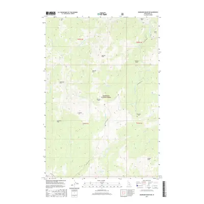
2017 Map of Magruder Mountain
USGS Topo · Published 2017About this map
The Bitterroot National Forest dominates this landscape, characterized by the high ridgelines and deep drainages of the Bitterroot Mountains. Central to the map is Magruder Mtn, surrounded by significant peaks including Deadtop Mtn and Salamander Butte. The area is defined by its network of water and terrain, with the Selway River and Little Clearwater River carving through the northern sections, while Gold Pan Lake and Elk Track Lakes provide isolated alpine water features to the south. Historically, the most prominent human marker is the Nez Perce Trail Rd, which snakes across the terrain, crossing through various gaps like Magruder Saddle and Kim Creek Saddle. This corridor represents a long-established route through the high country, connecting the various forks of Magruder Cr and the many named gulches that feed into the larger river systems.
Find a feature on this map
37 named features on this map. Tap any name to fly to it.
Don’t see what you’re looking for? This feature index may not catch every label — zoom into the map to look around manually.
Map Details
Editions of this 2017 Magruder Mountain Map
This is the sole edition of this map. No revisions or reprints were ever made.
Other maps of this area

1956 · Elk City
USGS Topo · 1:250,000

1960 · Elk City
USGS Topo · 1:250,000

1962 · Wood Hump
USGS Topo · 1:24,000

1962 · Beaver Jack Mtn
USGS Topo · 1:24,000

1966 · Spot Mountain
USGS Topo · 1:24,000

1966 · Three Prong Mountain
USGS Topo · 1:24,000
1966 · Burnt Strip Mtn
USGS Topo · 1:24,000

1978 · Dennis Mtn
USGS Topo · 1:24,000

1978 · Magruder Mtn
USGS Topo · 1:24,000
1979 · Sabe Mtn
USGS Topo · 1:24,000