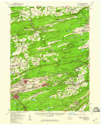
1955 Map of Mahanoy
USGS Topo · Published 1960About this map
Buck Mountain and the surrounding ridges of Schuylkill and Luzerne counties dominate this mid-century landscape, where coal extraction and rail transport define the regional economy. The map illustrates a complex network of industrial infrastructure, from the extensive Strip Mine operations near Hazle Valley to the vital transportation corridors of the Lehigh Valley Railroad, Pennsylvania Railroad, and the Central RR of New Jersey. Settlements like Shenandoah Heights and Oneida are tightly clustered amidst the topography, serving the nearby collieries and mines.
Find a feature on this map
175 named features on this map. Tap any name to fly to it.
Don’t see what you’re looking for? This feature index may not catch every label — zoom into the map to look around manually.
Map Details
Editions of this 1955 Mahanoy Map
This is the sole edition of this map. No revisions or reprints were ever made.
Other maps of this area

1889 · Catawissa
USGS Topo · 1:62,500

1889 · Hazleton
USGS Topo · 1:62,500

1889 · Pottsville
USGS Topo · 1:62,500

1891 · Wilkesbarre
USGS Topo · 1:62,500

1891 · Hazleton
USGS Topo · 1:62,500

1891 · Pottsville
USGS Topo · 1:62,500

1892 · Catawissa
USGS Topo · 1:62,500

1892 · Mahanoy
USGS Topo · 1:62,500

1892 · Pine Grove
USGS Topo · 1:62,500

1893 · Hazleton
USGS Topo · 1:62,500