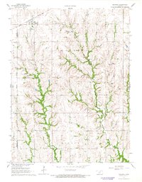
1966 Map of Mahaska
USGS Topo · Published 1967About this map
Mahaska sits at the northern edge of this Washington County landscape, a small prairie settlement defined by the diagonal passage of the Chicago Rock Island and Pacific railroad. The topography is deeply carved by a network of drainage systems, most notably the winding course of Mill Creek and smaller tributaries like Stanley Branch, Muddy, and Bowman. This 1960s survey illustrates a region strictly organized by the township and range system, with the Sixth Principal Meridian serving as a primary surveying benchmark along the western edge.
Find a feature on this map
15 named features on this map. Tap any name to fly to it.
Don’t see what you’re looking for? This feature index may not catch every label — zoom into the map to look around manually.
Map Details
Editions of this 1966 Mahaska Map
This is the sole edition of this map. No revisions or reprints were ever made.
Other maps of this area

1893 · Washington
USGS Topo · 1:125,000

1955 · Manhattan
USGS Topo · 1:250,000

1955 · Lincoln
USGS Topo · 1:250,000

1956 · Manhattan
USGS Topo · 1:250,000

1957 · Manhattan
USGS Topo · 1:250,000

1957 · Lincoln
USGS Topo · 1:250,000

1958 · Lincoln
USGS Topo · 1:250,000

1960 · Fairbury SW
USGS Topo · 1:24,000

1960 · Reynolds
USGS Topo · 1:24,000

1960 · Hubbell
USGS Topo · 1:24,000