
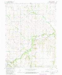
1960 Map of Hubbell
USGS Topo · Published 1961About this map
Hubbell serves as the primary hub in this corner of Thayer County, situated where the Chicago Burlington and Quincy railroad tracks cut across the plains just north of the Kansas border. This 1960 survey highlights a rural landscape defined by wide watercourses like Rose Creek and its tributaries, including Balls Branch and Humphrey Branch. The distribution of St Pauls Ch and local burial grounds like St Pauls Cem and Williams Cem underscores the generational footprint of early families who settled the townships of Gilead, Hubbell, and Albion. The presence of fine-dashed lines marking field and fence boundaries provides a rare glimpse into the mid-century agricultural layout, offering essential details for those tracing Nebraska homesteads or local family history before late-twentieth-century industrial farming consolidated many of these small plots.
Find a feature on this map
12 named features on this map. Tap any name to fly to it.
Don’t see what you’re looking for? This feature index may not catch every label — zoom into the map to look around manually.
Map Details
Editions of this 1960 Hubbell Map
2 editions found
Other maps of this area

1892 · Concordia
USGS Topo · 1:125,000

1893 · Washington
USGS Topo · 1:125,000

1898 · Hebron
USGS Topo · 1:125,000

1955 · Manhattan
USGS Topo · 1:250,000

1955 · Lincoln
USGS Topo · 1:250,000

1956 · Manhattan
USGS Topo · 1:250,000

1957 · Manhattan
USGS Topo · 1:250,000

1957 · Lincoln
USGS Topo · 1:250,000

1958 · Lincoln
USGS Topo · 1:250,000

1960 · Chester
USGS Topo · 1:24,000