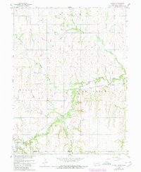
1960 Map of Hubbell
USGS Topo · Published 1980About this map
The borderlands of southern Nebraska and northern Kansas are defined by the winding course of Rose Creek as it moves through the townships of Hubbell, Rose Creek, and Albion. The village of Hubbell sits at the southwestern edge of the sheet, serving as a hub for the Burlington Northern railroad, which parallels the creek bed. This 1960 survey, later updated with photorevised data, captures the rural fabric of Gilead township through its family-named landmarks and essential community centers. Genealogists will find critical landmarks such as St Pauls Ch, St Pauls Cem, and Williams Cem. The landscape is etched by small drainage networks including Spring Branch, Balls Branch, and Humphrey Branch, illustrating the agricultural drainage patterns along the Thayer Co Republic Co line.
Find a feature on this map
17 named features on this map. Tap any name to fly to it.
Don’t see what you’re looking for? This feature index may not catch every label — zoom into the map to look around manually.
Map Details
Editions of this 1960 Hubbell Map
2 editions found

Other maps of this area

1892 · Concordia
USGS Topo · 1:125,000

1893 · Washington
USGS Topo · 1:125,000

1898 · Hebron
USGS Topo · 1:125,000

1955 · Manhattan
USGS Topo · 1:250,000

1955 · Lincoln
USGS Topo · 1:250,000

1956 · Manhattan
USGS Topo · 1:250,000

1957 · Manhattan
USGS Topo · 1:250,000

1957 · Lincoln
USGS Topo · 1:250,000

1958 · Lincoln
USGS Topo · 1:250,000

1960 · Chester
USGS Topo · 1:24,000