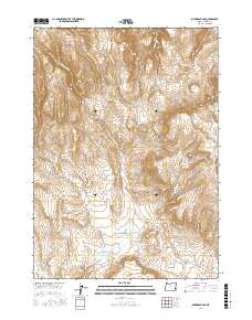
2017 Map of Mahogany Gap
USGS Topo · Published 2017About this map
Mahogany Mtn dominates this high-desert landscape in southeastern Oregon, standing as a prominent landmark in a region defined by its vital water sources and remote cattle-range infrastructure. The map documents the intricate network of drainages and springs essential to this arid environment, including Gap Spring, Ninemeyer Spring, and Old Maids Spring. Human passage through this terrain is carved out by practical routes like the Goodyear Cutoff and Mahogany Cutoff, which connect the scattered points of interest. Notable geographic features such as Old Maids Basin and the central Mahogany Gap reveal the natural corridors used by early travelers and ranchers. The presence of Hawks Nest Reservoir in the southwest further highlights the historic and modern efforts to manage water resources across this part of Malheur County.
Find a feature on this map
22 named features on this map. Tap any name to fly to it.
Don’t see what you’re looking for? This feature index may not catch every label — zoom into the map to look around manually.
Map Details
Editions of this 2017 Mahogany Gap Map
This is the sole edition of this map. No revisions or reprints were ever made.
Other maps of this area

1955 · Boise
USGS Topo · 1:250,000

1958 · Boise
USGS Topo · 1:250,000

1962 · Boise
USGS Topo · 1:250,000

1967 · Rockville
USGS Topo · 1:24,000
1967 · Bannock Ridge
USGS Topo · 1:24,000

1967 · Rooster Comb
USGS Topo · 1:24,000
1969 · Mahogany Gap
USGS Topo · 1:24,000

1969 · Mc Cain Creek
USGS Topo · 1:24,000
1969 · Hooker Creek
USGS Topo · 1:24,000

1969 · Cow Lakes
USGS Topo · 1:24,000