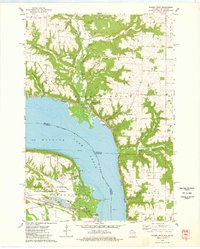
1974 Map of Maiden Rock
USGS Topo · Published 1978About this map
Lake Pepin dominates this stretch of the Mississippi River, creating a natural water boundary between Pierce County, Wisconsin, and Goodhue County, Minnesota. The 1970s landscape shows the village of Maiden Rock on the eastern shore, positioned at the mouth of the Rush River valley. On the Minnesota side, the distinct riverside character is shaped by Old Frontenac and the expansion of Frontenac State Park, which preserves the dramatic elevation of Garrard Bluff. Inland from the river, the topography is defined by deep coulees and ridges, such as Morgan Coulee and Warrentown Ridge, where small agricultural pockets like Salem and Foley persist. The transportation infrastructure of the era is clearly marked by the competing lines of the Burlington Northern and the C M StP & P railroads, tracing the banks on opposite sides of the water. Institutional history is noted at the Villa Maria Academy, while rural life is mapped through various gravel pits and local cemeteries like Maiden Rock Cem.
Find a feature on this map
49 named features on this map. Tap any name to fly to it.
Don’t see what you’re looking for? This feature index may not catch every label — zoom into the map to look around manually.
Map Details
Editions of this 1974 Maiden Rock Map
This is the sole edition of this map. No revisions or reprints were ever made.
Other maps of this area

1932 · Wabasha
USGS Topo · 1:62,500

1935 · Arkansaw
USGS Topo · 1:48,000

1940 · Maiden Rock
USGS Topo · 1:62,500

1941 · Arkansaw
USGS Topo · 1:62,500

1942 · Arkansaw
USGS Topo · 1:62,500

1950 · Maiden Rock
USGS Topo · 1:62,500

1951 · Wabasha
USGS Topo · 1:62,500

1951 · Lake City
USGS Topo · 1:62,500

1953 · Saint Paul
USGS Topo · 1:250,000

1959 · Saint Paul
USGS Topo · 1:250,000