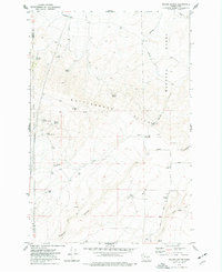
1974 Map of Maiden Spring
USGS Topo · Published 1977About this map
The Hanford Works occupies the eastern portion of this mid-1970s survey, marked by restricted access boundaries that contrast with the open agricultural and grazing land to the west. This arid landscape in the Rattlesnake Hills is defined by its critical water sources, including Maiden Spring, Joe Spring, and Railroad Spring, which likely supported early livestock operations. Evidence of rural infrastructure is found at Bennett Ranch, which is supported by a Grain Elevator and a dedicated Landing Strip. The presence of several named springs and the seasonal drainages of Sulphur Creek and Rattlesnake Cr reflect the challenges of managing land in this high-desert environment of Benton County. Deep cut features like Black Canyon and numerous jeep trails suggest a landscape used for both utility and remote resource management during the Cold War era.
Find a feature on this map
27 named features on this map. Tap any name to fly to it.
Don’t see what you’re looking for? This feature index may not catch every label — zoom into the map to look around manually.
Map Details
Editions of this 1974 Maiden Spring Map
This is the sole edition of this map. No revisions or reprints were ever made.
Other maps of this area

1915 · Prosser
USGS Topo · 1:125,000

1916 · Coyote Rapids
USGS Topo · 1:62,500

1917 · Priest Rapids
USGS Topo · 1:62,500

1917 · Prosser
USGS Topo · 1:125,000

1948 · Cairn Hope Peak
USGS Topo · 1:24,000

1948 · Emerson Nipple
USGS Topo · 1:24,000

1950 · Grandview
USGS Topo · 1:62,500

1951 · Priest Rapids
USGS Topo · 1:62,500

1951 · Grandview
USGS Topo · 1:62,500

1951 · Corral Canyon
USGS Topo · 1:62,500