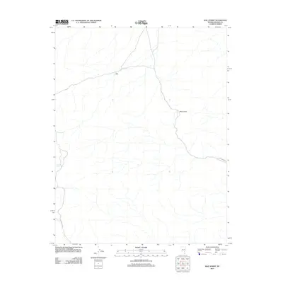
2012 Map of Mail Summit
USGS Topo · Published 2012About this map
Mail Summit serves as the central focal point of this Nevada landscape, located at the boundary of Lincoln and Nye counties. The terrain is defined by its arid drainage patterns and isolated water sources, specifically Henry Spring and Springer Spring, which were vital for early rangeland survival. Human activity is evidenced by the presence of Davis Cabin, a modest landmark along the winding Silver Canyon Rd. The network of unpaved paths, including Mail Summit Rd and Silver Creek Rd, highlights the historical routes used to navigate these high desert corridors. This survey provides a precise account of the region's topography and its sparse but essential infrastructure as it existed in the early 21st century.
Find a feature on this map
7 named features on this map. Tap any name to fly to it.
Don’t see what you’re looking for? This feature index may not catch every label — zoom into the map to look around manually.
Map Details
Editions of this 2012 Mail Summit Map
This is the sole edition of this map. No revisions or reprints were ever made.
Other maps of this area

1954 · Caliente
USGS Topo · 1:250,000

1959 · Caliente
USGS Topo · 1:250,000

1970 · Seaman Wash
USGS Topo · 1:24,000

1970 · Fossil Peak
USGS Topo · 1:24,000

1970 · Hiko
USGS Topo · 1:24,000

1985 · Mail Summit
USGS Topo · 1:24,000
1985 · Mount Irish
USGS Topo · 1:24,000
1985 · Crescent Spring
USGS Topo · 1:24,000
1985 · Mount Irish SE
USGS Topo · 1:24,000

1985 · Murphy Gap
USGS Topo · 1:24,000