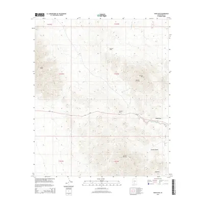
2014 Map of Maish Vaya
USGS Topo · Published 2014About this map
Maish Vaya and surrounding settlements occupy a high desert landscape defined by ephemeral waterways and stark mountain rises. In this 2014 survey, the primary east-west artery of Az-86 cuts through the Quijotoa Pass, connecting the valley floor with the scattered communities of Quijotoa and Narcho Santos. The drainage patterns are clearly delineated by the Santa Rosa Wash, which flows southward into Brownell Valley, and the Quijotoa Wash, which follows the southern contours of the Brownell Mountains. The terrain transitions from the sharp elevations of Sierra Blanca and Brownell Peak down to the alluvial plains where Bia-32 provides local access to tribal lands. This map details the intersection of modern state roads with traditional landscape corridors and washes that have long shaped navigation in the Sonoran desert.
Find a feature on this map
20 named features on this map. Tap any name to fly to it.
Don’t see what you’re looking for? This feature index may not catch every label — zoom into the map to look around manually.
Map Details
Editions of this 2014 Maish Vaya Map
This is the sole edition of this map. No revisions or reprints were ever made.
Other maps of this area

1953 · Ajo
USGS Topo · 1:250,000

1957 · Ajo
USGS Topo · 1:250,000

1958 · Ajo
USGS Topo · 1:250,000

1962 · Ajo
USGS Topo · 1:250,000

1963 · Ajo
USGS Topo · 1:250,000

1963 · Gu Achi
USGS Topo · 1:62,500

1963 · Quijotoa Mts
USGS Topo · 1:62,500

1963 · Cimarron Peak
USGS Topo · 1:62,500

1963 · Pisinimo
USGS Topo · 1:62,500

1967 · Ajo
USGS Topo · 1:250,000
Featured Places
- Maish Vaya, Gu Achi District
- Pisinemo District, AZ
- Gu Achi District, AZ
- Sells, AZ
- Narcho Santos, Gu Achi District