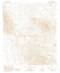
1990 Map of Maish Vaya
USGS Topo · Published 1990About this map
Papago Indian Reservation territory defines this 1990 survey, a landscape of desert basins and steep ranges in southern Arizona. The map centers on the Santa Rosa Wash, which cuts through the Brownell Valley between the Brownell Mountains and the Quijotoa Mountains. Small indigenous settlements like Stoa Vaya, Maish Vaya, and Narcho Santos are connected by a network of unimproved 4WD tracks, reflecting the sparse, traditional residency patterns of the era. The terrain is marked by an extensive history of mineral exploration, evidenced by dozens of mining features ranging from the Black Prince Mine in the Sierra Blanca to various Strip Mines and an Open Pit Mine further south. These numerous Prospect and Adit labels suggest a landscape deeply scarred by prospectors and small-scale operations across the Quijotoa region.
Find a feature on this map
30 named features on this map. Tap any name to fly to it.
Don’t see what you’re looking for? This feature index may not catch every label — zoom into the map to look around manually.
Map Details
Editions of this 1990 Maish Vaya Map
This is the sole edition of this map. No revisions or reprints were ever made.
Other maps of this area

1953 · Ajo
USGS Topo · 1:250,000

1957 · Ajo
USGS Topo · 1:250,000

1958 · Ajo
USGS Topo · 1:250,000

1962 · Ajo
USGS Topo · 1:250,000

1963 · Ajo
USGS Topo · 1:250,000

1963 · Gu Achi
USGS Topo · 1:62,500

1963 · Quijotoa Mts
USGS Topo · 1:62,500

1963 · Cimarron Peak
USGS Topo · 1:62,500

1963 · Pisinimo
USGS Topo · 1:62,500

1967 · Ajo
USGS Topo · 1:250,000
Featured Places
- Maish Vaya, Gu Achi District
- Narcho Santos, Gu Achi District
- Gu Achi District, AZ
- Quijotoa, Sells
- Sells, AZ