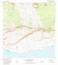
1981 Map of Makaopuhi Crater
USGS Topo · Published 1983About this map
Hawaii Volcanoes National Park dominates this landscape, showing a remarkably active geologic period along the East Rift Zone. The map meticulously records recent volcanic activity, including the Lava Flow of 1969 and subsequent eruptions through 1974 that reshaped the terrain between the Chain of Craters and the coast. Cultural sites are noted as historic footprints, such as Keauhou Landing (Site) and Kealakomo (Site) along the Pacific shore, which contrast with the active ranching at Ainahou Ranch. Dramatic topographic shifts occur at the Holei Pali and Poliokeawe Pali escarpments, where the Chain of Craters Road descends toward the sea. The cartography provides a primary record of how massive shield volcano features like Makaopuhi Crater and Mauna Ulu physically altered the islands' road networks and coastal access in the late twentieth century.
Find a feature on this map
40 named features on this map. Tap any name to fly to it.
Don’t see what you’re looking for? This feature index may not catch every label — zoom into the map to look around manually.
Map Details
Editions of this 1981 Makaopuhi Crater Map
3 editions found
Other maps of this area

1921 · Kilauea
USGS Topo · 1:62,500

1922 · Puna
USGS Topo · 1:62,500

1923 · Pahala
USGS Topo · 1:62,500

1924 · Kilauea
USGS Topo · 1:62,500

1924 · Puna
USGS Topo · 1:62,500

1954 · Hawaii South
USGS Topo · 1:250,000

1959 · Hawaii South
USGS Topo · 1:250,000

1961 · Hawaii South
USGS Topo · 1:250,000

1962 · Hawaii South
USGS Topo · 1:250,000
1963 · Volcano
USGS Topo · 1:24,000