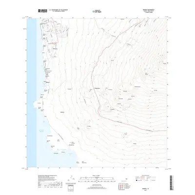
2017 Map of Makena
USGS Topo · Published 2017About this map
Wailea and its modern resort development sit along the northwestern coast of this Maui map, contrasting sharply with the rural uplands and the volcanic coastal reaches to the south. The shoreline transitions from popular beaches like Keawakapu Beach and Wailea Beach into the more rugged and traditional landscape of Makena. Moving inland, the elevation rises toward the community of 'Ulupalakua, where the Keekeehia Cem is located along the winding mountain roads. This 2017 survey documents the intersection of modern coastal expansion and long-standing Hawaiian place names, particularly around the protected waters of La Perouse Bay and Cape Kīna'u. Historical features like Halua Pond and the coastal settlement of Keone'ō'io remain visible, reflecting the area's significance before the modern era of tourism redefined the coastline.
Find a feature on this map
90 named features on this map. Tap any name to fly to it.
Don’t see what you’re looking for? This feature index may not catch every label — zoom into the map to look around manually.
Map Details
Editions of this 2017 Makena Map
This is the sole edition of this map. No revisions or reprints were ever made.
Other maps of this area

1954 · Maui
USGS Topo · 1:250,000

1954 · Maalaea
USGS Topo · 1:24,000

1954 · Puu O Kali
USGS Topo · 1:24,000

1954 · Makena
USGS Topo · 1:24,000

1957 · Kilohana
USGS Topo · 1:24,000

1957 · Lualailua Hills
USGS Topo · 1:24,000

1966 · Maui
USGS Topo · 1:250,000

1974 · Maui
USGS Topo · 1:250,000
1983 · Lualailua Hills
USGS Topo · 1:24,000
1983 · Maalaea
USGS Topo · 1:24,000