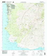
1995 Map of Makena
USGS Topo · Published 1999About this map
The southwest coast of Maui is documented here in the mid-1990s, showcasing a landscape defined by volcanic geology and traditional land divisions. Coastal developments such as Wailea and Makena contrast with the largely untouched volcanic fields of the Ahihi Kinau Natural Area Reserve. Moving inland, the terrain rises sharply toward the slopes of Haleakalā, where several large ahupua'a divisions—including Keauhou, Kalihi, and Papaanui—are clearly delineated.
Find a feature on this map
84 named features on this map. Tap any name to fly to it.
Don’t see what you’re looking for? This feature index may not catch every label — zoom into the map to look around manually.
Map Details
Editions of this 1995 Makena Map
This is the sole edition of this map. No revisions or reprints were ever made.
Other maps of this area

1954 · Maui
USGS Topo · 1:250,000

1954 · Maalaea
USGS Topo · 1:24,000

1954 · Puu O Kali
USGS Topo · 1:24,000

1954 · Makena
USGS Topo · 1:24,000

1957 · Kilohana
USGS Topo · 1:24,000

1957 · Lualailua Hills
USGS Topo · 1:24,000

1966 · Maui
USGS Topo · 1:250,000

1974 · Maui
USGS Topo · 1:250,000
1983 · Lualailua Hills
USGS Topo · 1:24,000
1983 · Maalaea
USGS Topo · 1:24,000