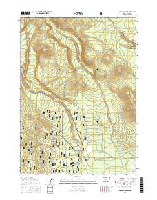
2017 Map of Maklaks Crater
USGS Topo · Published 2017About this map
Crater Lake National Park and the adjacent Winema National Forest dominate this high-altitude landscape in the southern Cascade Range. The map details a volcanic geography defined by prominent features like Maklaks Crater and Crater Peak, alongside the dramatic erosional formations of The Pinnacles within Pinnacle Valley. Hydrological patterns show the headwaters of Annie Creek and Sun Creek carving deep drainage channels through the pumice and ash deposits characteristic of the region. A network of forest service routes and winter trails, including the Boundary Tour and Diamond Lake Snomo route, indicates how the area is managed for both preservation and seasonal recreation. High passes such as Tututni Pass and Maklaks Pass provide critical navigation points across the ridgelines of Vidae Ridge and Grayback Ridge, illustrating the challenging transit routes used by both naturalists and foresters.
Find a feature on this map
47 named features on this map. Tap any name to fly to it.
Don’t see what you’re looking for? This feature index may not catch every label — zoom into the map to look around manually.
Map Details
Editions of this 2017 Maklaks Crater Map
This is the sole edition of this map. No revisions or reprints were ever made.
Other maps of this area

1889 · Klamath
USGS Topo · 1:250,000

1891 · Ashland
USGS Topo · 1:250,000

1893 · Ashland
USGS Topo · 1:250,000

1894 · Klamath
USGS Topo · 1:250,000

1897 · Ashland
USGS Topo · 1:250,000

1955 · Pelican Butte
USGS Topo · 1:62,500

1955 · Klamath Falls
USGS Topo · 1:250,000

1955 · Medford
USGS Topo · 1:250,000

1957 · Medford
USGS Topo · 1:250,000

1957 · Chiloquin
USGS Topo · 1:62,500