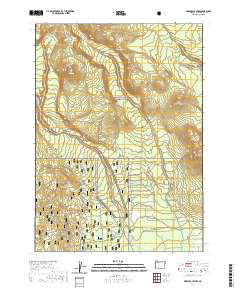
2020 Map of Maklaks Crater
USGS Topo · Published 2020About this map
Crater Lake National Park and Winema National Forest dominate this high-altitude landscape, where volcanic topography creates a complex network of ridges and passes. The prominent Maklaks Crater and Crater Peak serve as primary landmarks, connected by the Crater Peak Fire Road and the Crater Peaktrail. Water features are sparse but significant at this elevation, including Maklaks Spring and the drainage of Annie Cr, which forms the notable Annie Falls.
Find a feature on this map
30 named features on this map. Tap any name to fly to it.
Don’t see what you’re looking for? This feature index may not catch every label — zoom into the map to look around manually.
Map Details
Editions of this 2020 Maklaks Crater Map
This is the sole edition of this map. No revisions or reprints were ever made.
Other maps of this area

1889 · Klamath
USGS Topo · 1:250,000

1891 · Ashland
USGS Topo · 1:250,000

1893 · Ashland
USGS Topo · 1:250,000

1894 · Klamath
USGS Topo · 1:250,000

1897 · Ashland
USGS Topo · 1:250,000

1955 · Pelican Butte
USGS Topo · 1:62,500

1955 · Klamath Falls
USGS Topo · 1:250,000

1955 · Medford
USGS Topo · 1:250,000

1957 · Medford
USGS Topo · 1:250,000

1957 · Chiloquin
USGS Topo · 1:62,500