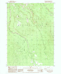
1985 Map of Maklaks Crater
USGS Topo · Published 1985About this map
Crater Peak and Maklaks Crater dominate the high ridges of this volcanic landscape during the mid-1980s. The terrain is defined by the sharp transition between the southern reaches of Crater Lake National Park and the adjacent Winema National Forest. This survey documents a wilderness area largely shaped by natural features and historical land divisions, most notably the Old Indian Reservation Boundary that cuts across the timbered slopes of Grayback Ridge.
Find a feature on this map
28 named features on this map. Tap any name to fly to it.
Don’t see what you’re looking for? This feature index may not catch every label — zoom into the map to look around manually.
Map Details
Editions of this 1985 Maklaks Crater Map
This is the sole edition of this map. No revisions or reprints were ever made.
Other maps of this area

1889 · Klamath
USGS Topo · 1:250,000

1891 · Ashland
USGS Topo · 1:250,000

1893 · Ashland
USGS Topo · 1:250,000

1894 · Klamath
USGS Topo · 1:250,000

1897 · Ashland
USGS Topo · 1:250,000

1955 · Pelican Butte
USGS Topo · 1:62,500

1955 · Klamath Falls
USGS Topo · 1:250,000

1955 · Medford
USGS Topo · 1:250,000

1957 · Medford
USGS Topo · 1:250,000

1957 · Chiloquin
USGS Topo · 1:62,500