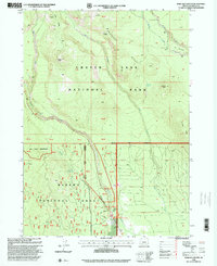
1998 Map of Maklaks Crater
USGS Topo · Published 2000About this map
Crater Lake National Park and the Winema National Forest dominate this landscape, capturing the geological and recreational character of the region in the late 1990s. The map highlights the volcanic geography of the southern Cascades, centered on Maklaks Crater and Crater Peak. This area is defined by the headwaters of several drainages, including Annie Creek, which flows south through the Annie Creek Water Recreation Area, and Sand Creek, which carves through the distinct formations of The Pinnacles. High-elevation crossings like Tututni Pass and Maklaks Pass connect the steep ridges of Vidae Ridge and Grayback Ridge. The transition from the high-alpine park environment into the Sky Lakes Wilderness is clearly delineated, showing a network of trails and springs, such as Cedar Spring and Maklaks Spring, that supported back-country exploration and forest management during this era.
Find a feature on this map
26 named features on this map. Tap any name to fly to it.
Don’t see what you’re looking for? This feature index may not catch every label — zoom into the map to look around manually.
Map Details
Editions of this 1998 Maklaks Crater Map
This is the sole edition of this map. No revisions or reprints were ever made.
Other maps of this area

1889 · Klamath
USGS Topo · 1:250,000

1891 · Ashland
USGS Topo · 1:250,000

1893 · Ashland
USGS Topo · 1:250,000

1894 · Klamath
USGS Topo · 1:250,000

1897 · Ashland
USGS Topo · 1:250,000

1955 · Pelican Butte
USGS Topo · 1:62,500

1955 · Klamath Falls
USGS Topo · 1:250,000

1955 · Medford
USGS Topo · 1:250,000

1957 · Medford
USGS Topo · 1:250,000

1957 · Chiloquin
USGS Topo · 1:62,500