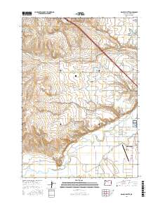
2017 Map of Malheur Butte
USGS Topo · Published 2017About this map
Malheur Butte stands as a prominent volcanic landmark overlooking an intricate network of irrigation and drainage systems crucial to the agriculture of Malheur County. This 2017 survey details the complex water management infrastructure that has shaped the region, including the Owyhee Canal, the Malheur Siphon, and the Brosnan Ditch. These man-made channels cut through the dry terrain, feeding the valley between Alkali Gulch and the Malheur River.
Find a feature on this map
60 named features on this map. Tap any name to fly to it.
Don’t see what you’re looking for? This feature index may not catch every label — zoom into the map to look around manually.
Map Details
Editions of this 2017 Malheur Butte Map
This is the sole edition of this map. No revisions or reprints were ever made.
Other maps of this area

1897 · Weiser
USGS Topo · 1:125,000

1898 · Nampa
USGS Topo · 1:125,000

1906 · Mitchell Butte
USGS Topo · 1:125,000

1951 · Moores Hollow
USGS Topo · 1:24,000

1951 · Malheur Butte
USGS Topo · 1:24,000

1951 · Moores Hollow
USGS Topo · 1:62,500

1951 · Payette
USGS Topo · 1:24,000

1951 · Weiser South
USGS Topo · 1:24,000

1955 · Baker
USGS Topo · 1:250,000

1955 · Boise
USGS Topo · 1:250,000