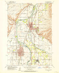
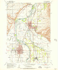
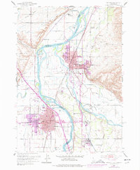
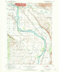
1951 Map of Payette
USGS Topo · Published 1953About this map
The Snake River serves as the centerpiece of this 1951 landscape, defining the jagged border between Oregon and Idaho. This era showcases a thriving agricultural and transportation hub, where the Union Pacific Railroad and the Old Oregon Trail Highway converge at the settlements of Payette and Ontario. The intricate irrigation network, featuring the Lower Ditch, Pioneer Ditch, and Washoe Ditch, reveals the intensive effort required to transform the arid river valley into productive farmland. Large river islands such as Ontario Island and Welch Island punctuate the confluence where the Payette River and Malheur River meet the main stem.
Find a feature on this map
67 named features on this map. Tap any name to fly to it.
Don’t see what you’re looking for? This feature index may not catch every label — zoom into the map to look around manually.
Map Details
Editions of this 1951 Payette Map
3 editions found
Other maps of this area

1897 · Weiser
USGS Topo · 1:125,000

1898 · Nampa
USGS Topo · 1:125,000

1906 · Mitchell Butte
USGS Topo · 1:125,000
1951 · Moores Hollow
USGS Topo · 1:24,000

1951 · Malheur Butte
USGS Topo · 1:24,000

1951 · Moores Hollow
USGS Topo · 1:62,500
1951 · Weiser South
USGS Topo · 1:24,000

1952 · Weiser Cove
USGS Topo · 1:24,000
1952 · Birding Island
USGS Topo · 1:24,000

1955 · Baker
USGS Topo · 1:250,000