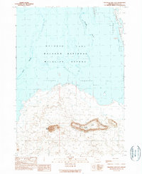
1990 Map of Malheur Lake East
USGS Topo · Published 1990About this map
Malheur National Wildlife Refuge dominates this high-desert landscape in southeastern Oregon, where the fluctuating waters of Malheur Lake meet the eastern edge of the Harney Valley. The map details a transition from the marshy expanses and islands like Pelican Island and Cole Island to the elevated terrain of Black Butte and Black Butte Ridge. This 1990 provisional survey records a landscape defined by water management and ranching, evidenced by the scattered Stock Pond and Stock Tank locations across the flats. The shoreline data, sourced from mid-1970s and early-1980s aerial photography, captures the variable nature of the lake's boundaries, providing an important record for those studying the hydrologic history and land use of this protected habitat south of the South of Malheur Lake region.
Find a feature on this map
13 named features on this map. Tap any name to fly to it.
Don’t see what you’re looking for? This feature index may not catch every label — zoom into the map to look around manually.
Map Details
Editions of this 1990 Malheur Lake East Map
This is the sole edition of this map. No revisions or reprints were ever made.
Other maps of this area

1955 · Burns
USGS Topo · 1:250,000

1958 · Burns
USGS Topo · 1:250,000

1959 · Burns
USGS Topo · 1:250,000

1959 · Lawen
USGS Topo · 1:62,500

1960 · Crane
USGS Topo · 1:62,500

1967 · Jackass Butte NE
USGS Topo · 1:24,000

1967 · Barton Lake
USGS Topo · 1:24,000

1967 · Adobe Flat
USGS Topo · 1:24,000

1978 · Malheur Lake
USGS Topo · 1:100,000
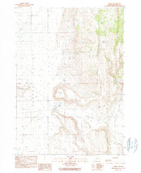
1990 · Crane
USGS Topo · 1:24,000