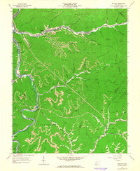
1963 Map of Mallory
USGS Topo · Published 1965About this map
Guyandotte River and the winding course of Buffalo Creek define this coal-rich landscape at the height of the mid-century energy boom. The extraction industry is visible everywhere, from the Strip Mine operations near Huff Junction to the numerous gas wells dotting Triadelphia Mountain and Stafford Mountain. Transportation follows the narrow valley floors, where the C & O and Norfolk And Western railroads link a string of company towns and settlements like Mallory, Davin, and Landville.
Find a feature on this map
91 named features on this map. Tap any name to fly to it.
Don’t see what you’re looking for? This feature index may not catch every label — zoom into the map to look around manually.
Map Details
Editions of this 1963 Mallory Map
2 editions found
Other maps of this area

1891 · Oceana
USGS Topo · 1:125,000

1893 · Oceana
USGS Topo · 1:125,000

1898 · Oceana
USGS Topo · 1:125,000

1909 · Gilbert
USGS Topo · 1:48,000

1910 · Pineville
USGS Topo · 1:48,000

1910 · Bald Knob
USGS Topo · 1:48,000

1912 · Bald Knob
USGS Topo · 1:62,500

1912 · Gilbert
USGS Topo · 1:62,500

1912 · Pineville
USGS Topo · 1:62,500

1913 · Logan
USGS Topo · 1:62,500