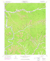
1963 Map of Mallory
USGS Topo · Published 1978About this map
The Guyandotte River snakes through the heart of this Appalachian landscape, serving as the corridor for the C & O railroad and a string of coal-era settlements. In the mid-twentieth century, communities like Mallory, Davin, and Mineral City followed the narrow valley floor of Huff Creek, while Greenville and Landville lined the river banks. This survey captures a significant transition in the landscape; purple photo-revisions from the late 1970s indicate a large area destined for submergence by the R. P. Bailey Dam.
Find a feature on this map
86 named features on this map. Tap any name to fly to it.
Don’t see what you’re looking for? This feature index may not catch every label — zoom into the map to look around manually.
Map Details
Editions of this 1963 Mallory Map
2 editions found
Other maps of this area

1891 · Oceana
USGS Topo · 1:125,000

1893 · Oceana
USGS Topo · 1:125,000

1898 · Oceana
USGS Topo · 1:125,000

1909 · Gilbert
USGS Topo · 1:48,000

1910 · Pineville
USGS Topo · 1:48,000

1910 · Bald Knob
USGS Topo · 1:48,000

1912 · Bald Knob
USGS Topo · 1:62,500

1912 · Gilbert
USGS Topo · 1:62,500

1912 · Pineville
USGS Topo · 1:62,500

1913 · Logan
USGS Topo · 1:62,500