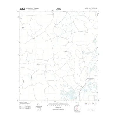
2012 Map of Mallory Swamp SE
USGS Topo · Published 2012About this map
Mallory Swamp dominates this low-lying landscape in Dixie County, Florida, where a network of water bodies and hunting camps defines the rural character of the region. Primitive roads and historical logging routes, such as Wilson Tram Rd and Tiger Ridge Rd, crisscross the wetlands, connecting isolated outposts like McElvain Camp and Cow Camp. The eastern portion of the map is particularly dense with named ponds and lakes, including Cemetery Lake, Governor Hill Lake, and Mill Pond, indicating a terrain where water management and seasonal drainage are central to the land's utility. Significant portions of the western reach are protected within the Steinhatchee Wildlife Area. The presence of features like Deserters Hammock and Tomlinson Prairie highlights the varied subtropical environments found in this part of the Florida Panhandle's interior.
Find a feature on this map
29 named features on this map. Tap any name to fly to it.
Don’t see what you’re looking for? This feature index may not catch every label — zoom into the map to look around manually.
Map Details
Editions of this 2012 Mallory Swamp SE Map
This is the sole edition of this map. No revisions or reprints were ever made.
Other maps of this area

1954 · Mallory Swamp NW
USGS Topo · 1:24,000

1954 · Cross City West
USGS Topo · 1:24,000

1954 · Cross City East
USGS Topo · 1:24,000

1954 · Mallory Swamp SW
USGS Topo · 1:24,000

1954 · Mallory Swamp SE
USGS Topo · 1:24,000

1954 · Mallory Swamp NE
USGS Topo · 1:24,000

1954 · Gainesville
USGS Topo · 1:250,000
1956 · Mallory Swamp NW
USGS Topo · 1:25,000

1956 · Mallory Swamp SE
USGS Topo · 1:25,000

1958 · Gainesville
USGS Topo · 1:250,000