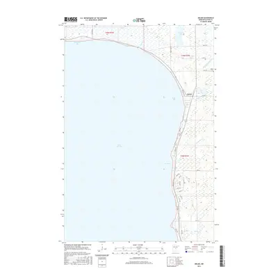
2016 Map of Malmo
USGS Topo · Published 2016About this map
Mille Lacs Lake dominates this 2016 survey, with its sprawling eastern shoreline punctuated by Bergstrom Bay, Malmo Bay, and Agate Bay. The settlement of Malmo serves as the primary hub for this lakeside community, situated near the intersection of several local routes. The landscape transition from the deep waters of the lake to the wetland environments of Mille-lacs Meadows and the smaller inland basins of Twenty Lake and Deer Lake illustrates the complex glacial topography of Aitkin County. Genealogists and local historians can find the Malmo Cem positioned just north of the village. The map also records the hydrological network of the area, including Reddy Cr, Seventeen Cr, and Peterson Cr, along with numerous residential roads such as Pebble Beach Rd and Willow Rd that reflect the area's development as a seasonal and permanent residential destination.
Find a feature on this map
38 named features on this map. Tap any name to fly to it.
Don’t see what you’re looking for? This feature index may not catch every label — zoom into the map to look around manually.
Map Details
Editions of this 2016 Malmo Map
This is the sole edition of this map. No revisions or reprints were ever made.
Other maps of this area

1916 · Wealthwood
USGS Topo · 1:62,500

1953 · Duluth
USGS Topo · 1:250,000

1958 · Duluth
USGS Topo · 1:250,000

1968 · Onamia NW
USGS Topo · 1:24,000

1968 · Wahkon North
USGS Topo · 1:24,000

1968 · Isle
USGS Topo · 1:24,000

1969 · Thor SW
USGS Topo · 1:24,000

1969 · Thor
USGS Topo · 1:24,000
1973 · Glen
USGS Topo · 1:24,000
1973 · Malmo
USGS Topo · 1:24,000