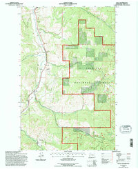
1992 Map of Malo
USGS Topo · Published 1996About this map
Malo sits at the junction of mountain valley drainages in Ferry County, where the Curlew Creek corridor provides a natural passage through the high country. This early 1990s landscape is defined by the extensive Colville National Forest boundary, which encompasses much of the eastern and southern terrain. The map reveals a legacy of resource extraction, with features like a Mineshaft, Prospect, and Quarry indicating the area's mining history, while a Grave Pit and a local Cemetery near the townsite provide specific points of interest for genealogists.
Find a feature on this map
25 named features on this map. Tap any name to fly to it.
Don’t see what you’re looking for? This feature index may not catch every label — zoom into the map to look around manually.
Map Details
Editions of this 1992 Malo Map
This is the sole edition of this map. No revisions or reprints were ever made.
Other maps of this area

1904 · Republic
USGS Topo · 1:125,000

1936 · Marcus
USGS Topo · 1:96,000

1942 · Marcus
USGS Topo · 1:125,000

1948 · Curlew
USGS Topo · 1:62,500

1948 · Republic
USGS Topo · 1:62,500

1948 · Sherman Peak
USGS Topo · 1:62,500

1948 · Togo Mountain
USGS Topo · 1:62,500

1951 · Togo Mountain
USGS Topo · 1:62,500

1951 · Sherman Peak
USGS Topo · 1:62,500

1951 · Curlew
USGS Topo · 1:62,500