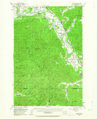
1953 Map of Malone
USGS Topo · Published 1963About this map
The Chehalis River valley serves as a bustling industrial and transit corridor in the early 1950s, defined by three competing rail lines: the Union Pacific, the Northern Pacific, and the Chicago Milwaukee St Paul and Pacific. Small communities like Malone, Porter, and Saginaw follow the river's path, while the uplands transition into the Capitol State Forest and the State Furbearing Animal Refuge. In the southwest corner, the North River Consolidated Sch marks a remote outpost of settlement near the North River. Local life is further evidenced by the Sharon Ch and Sharon Cem near the riverbanks. The map also captures specialized land use, including the Chehalis Indian Reservation and the Wenzel Springs Pumping Sta, alongside natural landmarks like Minot Peak and Blue Mtn.
Find a feature on this map
70 named features on this map. Tap any name to fly to it.
Don’t see what you’re looking for? This feature index may not catch every label — zoom into the map to look around manually.
Map Details
Editions of this 1953 Malone Map
3 editions found

Other maps of this area

1939 · Shelton
USGS Topo · 1:62,500

1940 · Montesano
USGS Topo · 1:62,500

1941 · Walville
USGS Topo · 1:62,500

1941 · Meskill
USGS Topo · 1:62,500

1941 · Mobray
USGS Topo · 1:62,500

1941 · Gate
USGS Topo · 1:62,500

1941 · Ford
USGS Topo · 1:62,500

1943 · Nahwatzel Lake
USGS Topo · 1:62,500

1943 · Mobray
USGS Topo · 1:62,500

1953 · Hoquiam
USGS Topo · 1:250,000