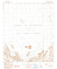
1990 Map of Malpais Hill
USGS Topo · Published 1990About this map
The Crater Range dominates the southern landscape of this Arizona survey, its jagged topography rising sharply above the desert floor. This 1990 provisional map documents a portion of the Barry M Goldwater Air Force Range, an area largely defined by its military boundaries and natural obstacles. The northern section is marked by the distinct prominence of Malpais Hill, a volcanic landmark standing isolated amidst the broad drainage patterns of the Midway Wash. The map reflects a landscape managed for defense purposes, where human presence is restricted to military use and the natural geography remains largely undisturbed. It provides a technical look at the intersection of steep mountain terrain and the expansive alluvial plains typical of the Maricopa County desert interior.
Find a feature on this map
6 named features on this map. Tap any name to fly to it.
Don’t see what you’re looking for? This feature index may not catch every label — zoom into the map to look around manually.
Map Details
Editions of this 1990 Malpais Hill Map
This is the sole edition of this map. No revisions or reprints were ever made.
Other maps of this area

1949 · Sentinel
USGS Topo · 1:62,500

1950 · Sentinel
USGS Topo · 1:62,500

1950 · Theba
USGS Topo · 1:62,500

1951 · Theba
USGS Topo · 1:62,500

1953 · Ajo
USGS Topo · 1:250,000

1957 · Ajo
USGS Topo · 1:250,000

1958 · Ajo
USGS Topo · 1:250,000

1958 · Midway
USGS Topo · 1:62,500

1962 · Ajo
USGS Topo · 1:250,000

1963 · Ajo
USGS Topo · 1:250,000